Scan to BIM workflow
Our Pointcloud services
In the construction process it is crucial that there is a clear view of the existing room or space. Besides that, revision is easier when there is a clear model of the existing situation. Bimservice makes this possible with the use of a Pointcloud. In a Pointcloud, rooms and objects are precisely displayed, using measurements that are done with a laserscanner. In this way a geometric representation that corresponds with reality can be created, to depict what the current situation looks like.
Using the method above, eventually the Pointcloud contains a million measurement points of objects and buildings. These can be used to depict a clear view of the existing situation. An example of use is when a monumental building needs renovation. If there are no drawings available for the current situation or when these drawings are not accurate enough, the Pointcloud help to identify and add the missing pieces. This geometric depiction of reality can serve as an addition to already existing pieces or as a replacement of the old ones. A Pointcloud could also be used for projects that are already finished, to evaluate the results and to make revision easier.
The use of Pointcloud scans within Revit helps to create precisely positioned and coordinated models. This results in a reliable model which can later be used for navigation and information processing. It also offers insight into discrepancies and clashes. The Pointcloud surveys and Scan to BIM models are especially useful for buildings where As-Built documentation is missing.
Input received
- Documentation in any format
- Pointclouds (or ask us to scan)
- Guidelines & instructions
Data processing & quality assurance
- Reviewing all received documentation
- Requesting missing information
- Coordination in Revit
- Positioning Pointcloud and modelling
- Discrepancy logs for problematic areas
- Synchronising with the clients needs and suggestions
Output deliverables
- 2D drawings
- 3D models in Revit
- Navisworks models
- CAD files if necessary
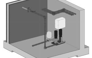
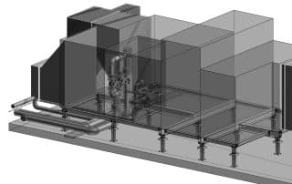
Some scan examples with detailing (LOD)